Student Science in Action at Mount St. Helens
February 12, 2019
CASEE is a unique program in the Battle Ground Public School District due to an emphasis on experience based learning and partnerships with local and state agencies. Over the years, CASEE has developed many projects to provide students with an opportunity to put into action the skills they learn in the classroom. One such project is the Mount St. Helens Institute’s Ecological Field Study conducted by CASEE Forestry students.
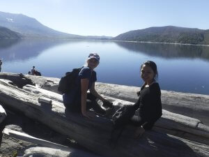
The project begins with an overnight field trip to Mount St. Helens. The first day is spent exploring the landscape impacted by the 1980 eruption and practicing essential skills for the field study. They spend the night at the Mount St. Helens Institute’s field camp near Windy Ridge where students and staff share a meal and enjoy s’mores and campfire sing alongs. On the second day students split into groups to collect field data at a number of study sites in different disturbance zones.
 What’s a disturbance zone? Most people know about the ash from the eruption and many know there was a devastating blast, but the eruption was much more complex. It started with a landslide. The northern slope of the mountain failed, 3.7 billion cubic yards of rock slid off the mountain and covered the landscape with debris an average of 150 feet deep from Spirit Lake to 14 miles down the North Fork Toutle River Valley. This opened the throat of the volcano causing rapid depressurization of built up gas and magma known as the lateral blast. The stone filled wind traveling 300 mph and reaching temperatures of 660°F pulverized everything in its path for 230 square miles. Interestingly, at its outer reaches the blast retained its heat but lost its force creating what’s known as the scorch zone. Around the edges trees were killed by the high temperatures but remained standing. All of this happened in a matter of seconds but the eruption was far from over. Just 15 minutes later there was an ash column 15 miles high which eventually deposited 1.4 billion cubic yards of ash over 22,000 square miles. Additionally, the mountain produced lava in the form of a pyroclastic flow creating the pumice plain and volcanic debris mixed with water to form lahars in several stream and river valleys around Mount St. Helens.
 Each eruption event had very different physical properties and subsequently had different effects on the landscape. CASEE students followed in the footsteps of hundreds of scientists as they set out to inventory and analyze how these differing effects as well as different land management techniques changed how the environment would recover from one of the world’s most famous volcanic eruptions.
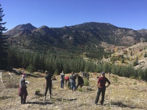
Students inventoried the species, size and number of trees and shrubs in their plot. They estimated the abundance of different life forms on the ground. They measured canopy cover density, slope and aspect of the site, and collected soil samples. It’s an all-day affair as each group visits two different sites to collect data for several hours. Study sites not only vary in the type of volcanic disturbance that occurred in 1980 but the land management practices before and after the eruption. Some sites were clear cut before the eruption, others were salvage logged after and still more were allowed to regenerate naturally. There are even a few sites in Christmas bough and timber plantations.
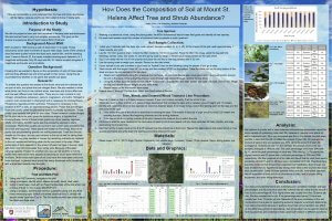
 CASEE forestry students joined students from schools around Mount St. Helens. Every student used the same protocol to collect data and the data was shared among all the students participating in the project. Back in the classroom the students formulated research questions to be answered by the data they took part in collecting. Topics ranged from how canopy cover affected the abundance of life forms on the ground to how does the type of trees growing in a plot affect the soil nutrient composition. After a crash course in Excel students were off and running to sort data and generate graphs that either supported or refuted their hypothesis. They researched the various ecological principles involved in their question to analyze their results. All of this hard work was compiled into a research poster to be presented at a student research conference at Washington State University in Vancouver.
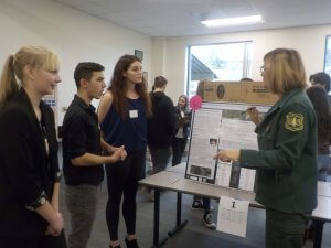 At the conference hosted by the Mount St. Helens Institute students have a chance to show off their research and see the work of other students. During the poster presentation several industry professionals join students to discuss their research. There is a career panel in which university students and professionals talk about their jobs and how they arrived there. Students have an opportunity to ask questions about careers and other opportunities they are interested in. This capstone event is unique among high school science projects in that it so realistically emulates how professional science is conducted in the real world.
 The Mount St. Helens Institute’s Ecological Field Study is an amazing project that showcases the dedication of CASEE staff and the program’s commitment to project based science and CTE curriculum. Students who have participated in this project have experienced scorching heat and freezing snow. They have endured the drama and frustration of data management and analysis. They know the disappointment of a hypothesis that is refuted by the data or asking a question that the data has no answer for. In the end, every student who has participated in the project has said they learned so much about science design, forestry concepts, and how to use technology to make an amazing presentation. They know they will use these important skills in the years to come. We thank the Battle Ground School District, Forest Service and Mount St. Helens Institute for continuing to support this powerful experience for CASEE students.